COMPANY
Basic Attitude
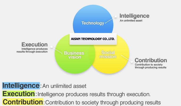
AISAN TECHNOLOGY has always aimed to be a business that is trusted by society through business activities based on “corporate policy and management philosophy.” Our philosophy concerning corporate social responsibility is not complicated – we have always recognized our activities as a social responsibility ever since our company was founded. We carry out our CSR activities in accordance with the spirit of “corporate policy and management philosophy.” Based on this basic philosophy, we have established a system of compliance and corporate governance, and have conducted business in accordance with social change through communication with our main stakeholders, in hope of realizing a sustainable society.
| Corporate Name | AISAN TECHNOLOGY Co., Ltd. |
|---|---|
| Representative | Atsushi Kato, President and Representative Director |
| Established | August 1970 |
| Capital Stock | 1,581.4 million yen |
| Securities Exchange Listed | Tokyo Stock Exchange, Inc.(JASDAQ market, Securities Code: 4667) |
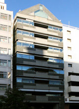
| Head Office Address | AT Bldg., 3-7-14, Nishiki, Naka-ku, Nagoya City, Aichi Prefecture
[Map]
TEL: +81-52-950-7500 (main) FAX: +81-52-950-7507 |
| No. of Employees | 107 (Male: 83 / Female: 24) ( as of March 31,2017 ) |
| Businesses |
|
| Main Banks | Bank of Tokyo-Mitsubishi UFJ, Bank of Nagoya, Aichi Bank |
| Main Clients | Mitsubishi Electric Corporation, Mitsubishi Electric Information Systems Corporation, Domestic Major Legal Affairs Bureaus, Group companies of Toyota Motor Corporation, Nissan Motor Co., Ltd., Group companies of Honda Motor Co., Ltd., Google Inc., Group companies of NTT Group, PASCO Corporation, NTT DATA Corporation, Autodesk, Inc., Annaka Co., Ltd., Leica Geosystems Co., Ltd., Leopalace21 Corporation, GENBA SUPPORT. CO., LTD. and more |
| Main Shareholders | Mitsubishi Electric Corporation, Mitsubishi Electric Information Systems Corporation (As of March 31, 2017) |
| Group Companies | AT Labo CO., LTD. |
| Threed CO., LTD. |
History
| 1970 | August | Kiyohisa Kato founded Aisan Co., Ltd. at 6-23, Nagato-cho, Showa-ku, Nagoya City |
|---|---|---|
| 1971 | October | Launched system development for surveyor/inspector practice |
| 1974 | June | Released a survey calculation program “Survey Calculation Sheet” |
| 1977 | February | Released a survey system “ABS” |
| 1982 | December | Released a survey system “NEW ABS” |
| 1983 | February | Went into the business of automatic drafter online computer system. Released an early basic CAD system “FINE-PLOT” |
| 1984 | May | Released a survey CAD system “WING" |
| July | Released a CAD system for large-scale automatic drafter | |
| 1985 | August | Spun off the system development division and founded Aisan Software Co., Ltd. (Capital: 2,000,000 yen, Address: Meito-ku, Nagoya City) |
| 1986 | August | Released a survey and design total automation system |
| 1987 | April | Released an automatic drafter “AI-1302 (Size: A2)," a self-developed utility model application product |
| 1988 | June | Released a survey CAD system “NEW WING” and a data collector“Mr.GENBA” |
| August | Spun off the sales division of Tokai area and founded an affiliate company Aisan Tokai Co., Ltd. (Capital: 8,000,000 yen, Address: Nato-ku, Nagoya City) | |
| 1989 | June | Released a survey CAD system “HYPER WING” |
| 1990 | June | Released drafting machines “AI-MIX0/AI-MIX1” |
| 1991 | April | Aisan Software Co., Ltd. founded a joint company “南通愛算計算機軟件有限公司” in China |
| May | The “Public Survey Total Station System HYPER WING” acquired “Ministry of Construction survey technology/technical review certification No. 0301” | |
| 1992 | January | Founded AISAN TECHNOLOGY Co., Ltd. (Capital: 10,000,000 yen, Address: Owariasahi City, Aichi Prefecture) as a survey software development company |
| August | Corporate name changed to “AISAN TECHNOLOGY Co., Ltd.” through merger of “Aisan Tokai Co., Ltd.” and “AISAN TECHNOLOGY Co., Ltd.” | |
| Main Office moved to 1-77, Higashi-honjigahara, Owariasahi City, Aichi Prefecture | ||
| 1994 | December | Released a survey CAD system “Pro Wing” |
| 1995 | April | Merged with the affiliate company Aisan Software Co., Ltd. |
| 1996 | May | Released a data collector “PT-WINDY” |
| 1997 | April | Stock registered with the Japan Securities Dealers Association for over-the-counter-trading |
| November | Released numerical topographical survey system Maps series “TS-Maps/DM-Maps/Geo-Maps” | |
| 1998 | December | Released AutoCAD/AutoCAD Map TM add-on tool “Geo Centric Series” |
| 1999 | February | Main Office moved to 3-7-14, Nishiki, Naka-ku, Nagoya City, Aichi Prefecture |
| August | Released a data collector for Windows CE “Field Solution” | |
| December | Released a survey results 2000 supporting tool “JGD2000 SolutionTool” | |
| 2000 | April | President and Representative Director Kiyohisa Kato assumed the position of Chairman, and Chief Director Hideo Jinbo assumed the position of President and Representative Director |
| July | Released a survey CAD system “WingNeo” and a system for real-estate surveyor “AT-WAIS” | |
| 2001 | October | Released total civil engineering management system “CVL-Manager M@TE” Series |
| 2002 | March | Released a web groupware “Everybody’s Office (Minna de Office)” |
| June | Tetsuji Yanagisawa assumed the position of President and Representative Director | |
| Released a coordination conversion software “Trans” Series (corresponding to the amended Survey Act) | ||
| August | Released a data collector for Windows CE “Field Solution II” | |
| October | Released a survey result electric delivery supporting filing system “FMS-Survey” | |
| December | Released an electronic plane pen computer system “FS-Maps” | |
| 2003 | October | Released a land survey map world coordinate plotting solution tool “Heisei Kenchi/BMB” |
| Implemented a stock issue (700,000 shares) towards Mitsubishi Electric Corporation, etc., through third-party allocation of shares | ||
| 2004 | June | Corporate capital exceeded 500,000,000 yen due to the third-party allocation of shares implemented October 2003: became a large-scale company specified by Japanese commercial law and established a board of auditors |
| September | Executed an agency agreement concerning “Mitsubishi Electric high precision GPS positioning service PAS” | |
| December | Cancelled the registration with the Japan Securities Dealers Association and listed on the Jasdaq Securities Exchange, Inc. | |
| 2005 | August | Acquired patents concerning survey site system (including patent-pending) reserved by Uto Kogyo Co., Ltd. (President: Michio Nishiyama, Main office: Toyonaka City, Osaka) |
| September | Changed the share unit number to 100 | |
| October | Executed an exclusive dealer contract with NTT DATA Corporation and started distribution of “GIS spatial data quality assessment tool.” | |
| Business collaboration concerning “Mitsubishi Electric position/time verification information provision service” and released “COCO-DATES M@TE” | ||
| December | Announced launch of the business concerning “online real estate registration support” | |
| 2006 | April | Released an online real estate registration application supporting software for private sector “WINGOLDIAR” |
| 2007 | January | Announced a business collaboration with Autodesk, Inc. |
| Acquired the Privacy Mark | ||
| March | Released an observation system “CVL-Manager Zero computer aided construction package” (corresponding to computer aided construction management guidelines) | |
| April | Released a real estate heading registration application software “Registration Supporting System” | |
| May | Announced business collaboration with Pro-firm Information Systems Corp. | |
| August | Released hybrid controller Pocket series “Pocket-neo/Pocket-PAS” | |
| December | Released AutoCAD Civil 3D add-on tool “3D Coordination Calculation for AutoCAD Civil 3D” | |
| 2008 | February | “Method for plotting global coordinates on a land survey map” acquired the patent No. 4088234 |
| October | Started business collaboration with GENBA SUPPORT. CO., LTD. | |
| Executed a distribution partner contract with Autodesk, Inc. | ||
| December | Started a business-academia collaboration with Tokyo University of Agriculture and Industry concerning “Development of handwriting electronic medical record system corresponding to ORCA for medical clinic” | |
| 2009 | January | Renewed the Privacy Mark |
| March | Released a survey CAD system “WingNeo6” | |
| April | “BMB world coordination acquisition system” acquired the construction technology testing certification | |
| November | Executed “Independent software vender bundle contract” with Autodesk, Inc. | |
| December | Spun off the distribution division at Okinawa area and founded an affiliate company AISAN NANBU HANBAI CO., LTD. (present consolidated subsidiary) | |
| 2010 | March | Released a survey CAD system “WingNeo7” |
| April | Listed on the Osaka Securities Exchange, JASDAQ (currently JASDAQ (standard section)) in accordance with the merger of JASDAQ Securities Exchange and Osaka Securities Exchange | |
| July | Announced business collaboration with CTS Co., Ltd. | |
| October | Founded an affiliate company AT Labo Co., Ltd. (present consolidated subsidiary) for research and development of next generation survey system | |
| November | Founded an affiliate company Threed Co., Ltd. (present consolidated subsidiary) for 3D survey business | |
| 2011 | March | Released a survey CAD system “WingNeo INFINITY” |
| July | Released a laser rangefinder “BAUMStation” through business collaboration with Leica Geosystems Co., Ltd. and KANSAIKOUJISOKURYOU Co., Ltd. | |
| 2012 | February | First release in Japan: “high precision independent positioning” system “QZS Prove Tool EX attached with GPS+QZS antenna receiver” which utilizes supporting data provided by Quasi-Zenith Satellite-1 “MICHIBIKI” |
| Released a handwriting electronic medical record system “Dr.HandzPen” | ||
| 2013 | July | Listed on the Tokyo Securities Exchange, JASDAQ (standard section) in accordance with the merger of Tokyo Securities Exchange and Osaka Securities Exchange |
Business Description
AISAN TECHNOLOGY’s customers are primarily involved in public works projects in the fields of “measurement/design,” “construction,” and “land and house investigation” pertaining to real estate registration. Our business is founded upon providing customers with “analysis technologies to determine position more accurately.” We offer multiple types of software and services as flexible solutions for various problems presented by different types of work necessary in each respective industry.
Our customers represent a market consisting of approximately 550,000 companies involved in the fields of surveying/designing, construction and construction consulting. There are approximately 18,000 licensed land and house investigators in Japan who specialize in real estate. We are also attempting to expand into new industries such as the automobile and health care industries.
Surveying system solutions
We develop and distribute applications for utilizing new surveying technologies, facilitating works, and reducing costs for types of work such as surveying, construction, and land and house investigation.
A new surveying system designated “Survey Results 2011” was adopted for the entire nation to address crustal movement caused by the Tohoku Earthquake that occurred March 11, 2011. The surveying system is an important criteria for administering the land of Japan. More than two years have passed since the shape of the Earth’s crust in the area was altered by the most disastrous earthquake on record and it is now necessary to correct coordinates and elevations that serve as public reference points administered by local governments. “PatchJGD” software has been provided by the Geospatial Information Authority of Japan to facilitate the work of correcting coordinates and elevations but it is not applicable to certain areas. Thus, it is necessary to conduct a “re-survey” by revising the measurements of some of the reference points.
When this “re-survey” became necessary, AISAN TECHNOLOGY created its own unique parameters, and along with releasing our epoch-making “3D-BMB Global Coordinates Acquisition System” software in November 2012 to support calculation of corrections adaptable to those areas, we also released a new version of our flagship product “WingNeoINFINITY,” that offers enhanced quality and function (WingNeoINFINITY Ver. 3) in March 2013. Together with actively persuading customers using the old version to upgrade to the new version, we held seminars in various areas all around the country for customers who were using products made by other companies in order to get them to adopt our software instead.
With the new version, in addition to facilitating operation of basic functions and supporting new technologies, a service to backup customer’s data in Google storage has been started. We will continue to offer total solutions for surveying that link site, office, and network for engineers who support documenting the physical features of Japan.
Calculation instrument solutions
By adding calculation instruments to our lineup as well as providing our customers with software, AISAN TECHNOLOGY hopes to provide customers with total support. Based on an alliance with Leica Geosystems, we are now also marketing “ATStation,” a non-prism, electro-optical distance meter that enhances efficiency of monitoring at surveying sites. By also offering Leica Geosystems’ motor-drive surveying instruments, GNSS surveying instruments, and high-accuracy laser scanners, we can respond to a wider range of customer needs.
The “ATStation” and motor-drive surveying instruments have dramatically enhanced efficiency of data collection, such as outdoor survey monitoring, by connecting with the “PocketNeo Series” which we developed and are now marketing. Unlike conventional data collectors, in addition to the observation data, data acquired at surveying sites, such as referencing boundary stakes and photographs, can be linked together with WingNeoINFINITY.
We are further expanding our line of solutions for pertinent fields, such as “BAUMStation,” which was released in July 2011. BAUMStation offers superior safety and work efficiency for monitoring related to dangerous disaster restoration work, such as taking measurements that requires setting a prism in dangerous places. “Standing measurement” of foundations made by driving stakes into the ground at the beginning of residential construction can now be accomplished by a single “BAUMStation” whereas the task used to require two surveying instruments.
High-accuracy 3D space data solutions
Our company group possesses several Mobile Mapping Systems (MMS), developed by Mitsubishi Electric Corporation, and is proactively expanding our 3D space data business in a wide range of industries. The MMS consists of 3 GPS units, 360 degrees cameras and laser scanners, etc., mounted on the roof of a vehicle, and is capable of measuring 3D space data with high precision at speeds ranging from 20 to 80 kilometers per hour without applying traffic restrictions.
The MMS developed by Mitsubishi Electric Corporation, in particular, enjoys a good reputation as a state-of-the-art system that can acquire space data with the highest precision and has a proven track record of having been approved for nation-wide public surveying by the Geospatial Information Authority of Japan.
As the authorized dealer for Mitsubishi Electric, our group proactively promotes measurement services using MMS including sales of MMS in Japan. We are also involved in development and marketing of applications for MMS.
ITS solutions
Automobile manufacturers are currently conducting research on ecological driving and automatic driving. One of the objectives of our group is to promote the research, and we are offering to use our MMS for high-accuracy 3D maps. The service is being used by several automobile manufacturers, providing them with various types of data to support their research activities. Attempting to further enhance precision, we are conducting research using data transmitted by the quasi-zenith satellite “MICHIBIKI.”
Medical solutions
Based on research results and experience, our group has begun working on medical solutions in the field of health care since 2011. Use of IT has rapidly accelerated for the health care industry along with advancements in cloud technology brought forth by the Great East Japan Earthquake and by current changes in general rules regarding online prescriptions. As a result of research and development using the world’s top “online handwriting recognition” technology developed by the Tokyo University of Agriculture and Technology (National University Corporation), our group began marketing an electronic medical record system “Dr.HandzPen” which was released in December 2011.
We have also begun developing and expanding solutions for various medical documents using handwritten character recognition and electronic signature technologies.